What is Ground Penetrating Radar?
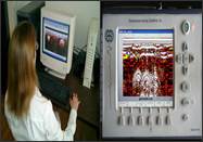
Ground penetrating radar (GPR) is a non-destructive geophysical method that produces a continuous cross-sectional profile or record of subsurface features, without drilling, probing, or digging. The GPR cross-section shows the ground surface at the top of the profile, and the reflections of subsurface geologic units and objects to a certain depth at the bottom.
Ground penetrating radar (GPR) profiles are used for evaluating the location and depth of buried objects and to investigate the presence and continuity of natural subsurface conditions and features.
Ground penetrating radar (GPR) is a tool for indirectly looking at underground objects (such as graves), gravel and sand layers, and other underground structures. The information or data received by GPR is like an x-ray or map of the underground. In fact, GPR uses electromagnetic (EM) waves, as x-ray machines do, but GPR uses radio waves, which have a longer wavelength (see Figure 1). The wavelength, or the length of one wave, is the fundamental difference between the forms of electromagnetic energy. For example, the wavelength of x-rays range from about 10 billionths of a meter to about 10 trillionths of a meter, whereas radio waves can be a few meters long.