
Earthquakes can happen suddenly, sometimes shaking the ground strongly enough to damage buildings, trigger landslides, or generate tsunamis. Yet many earthquakes are so small that people never notice them. Scientists can still detect these tiny movements using highly sensitive instruments known as seismographs or seismometers. 🌎🔬
These instruments allow researchers to measure vibrations traveling through Earth, determine where an earthquake occurred, estimate its size, and investigate the structure deep beneath our feet. But how can a machine detect movements that may be far too subtle for humans to feel?
The answer lies in a combination of physics, inertia, precise sensors, and careful analysis of seismic waves.
🌋 What Is a Seismograph?
A seismograph is an instrument used to detect and record vibrations of the ground. Those vibrations are often caused by earthquakes, but seismographs can also detect volcanic activity, explosions, landslides, mining operations, meteor impacts, and even some human-generated vibrations. 📡
Technically, scientists often distinguish between two related terms:
- A seismometer is the sensor that measures ground motion.
- A seismograph traditionally refers to the entire system that detects and records that motion.
In modern earthquake monitoring, the terms are sometimes used interchangeably.
The record produced by a seismograph is called a seismogram. It appears as a series of lines or waves showing how the ground moved over time. 📉
⚙️ The Basic Principle: Inertia
The fundamental principle behind a traditional seismograph is surprisingly simple: inertia.
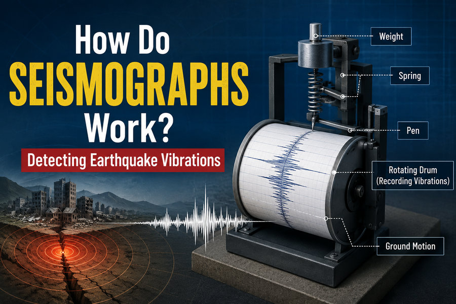
According to Newton’s laws of motion, an object tends to remain at rest unless a force acts upon it. Imagine a heavy weight suspended from a frame by a spring. The frame is firmly attached to the ground.
When an earthquake occurs, the ground—and therefore the frame—moves. However, the suspended mass tends to remain relatively stationary because of inertia.
This creates a difference in motion between the moving frame and the suspended mass.
A measuring system records that difference. 🧭
In early mechanical seismographs, a pen attached to the suspended mass drew a line on rotating paper. When the ground was calm, the pen produced a nearly straight line. When the ground shook, the paper moved underneath the relatively stable pen, producing a wavy pattern.
That pattern represented the earthquake vibrations.
📈 How Modern Seismometers Detect Movement
Modern seismometers are far more sophisticated than early mechanical instruments.
Instead of relying only on pens and paper, most modern systems use electronic sensors and digital recording equipment. These instruments can detect extremely small movements of the ground.
Many modern seismometers use electromagnetic systems. Inside the instrument, a mass moves relative to its surrounding frame. The motion can generate an electrical signal, which is converted into digital data.
Other instruments use specialized electronic feedback systems that keep the internal mass almost perfectly stationary. The amount of electrical force required to stabilize the mass tells scientists how strongly the ground is moving.
Computers continuously record and process the measurements. 💻🌍
Because of their extraordinary sensitivity, modern seismic instruments may detect earthquakes occurring thousands of kilometers away.
🌊 Seismic Waves: The Vibrations Seismographs Measure
When rocks suddenly break or slip along a fault, energy is released. That energy travels through Earth as seismic waves.
Seismographs detect several major types of seismic waves.
⚡ P Waves
Primary waves, or P waves, are usually the fastest seismic waves.
They compress and expand material in the same direction the wave is traveling, somewhat like the motion created when a spring is repeatedly pushed and pulled.
P waves can travel through:
- Solid rock
- Liquids
- Gases
Because they move fastest, they are normally the first earthquake waves recorded by a seismic station.
↕️ S Waves
Secondary waves, or S waves, arrive after P waves.
Rather than compressing the material in the direction of travel, S waves move particles sideways or vertically relative to the direction the wave travels.
Importantly, S waves cannot travel through liquids.
This fact has helped scientists discover important information about Earth’s interior, including evidence that Earth’s outer core is liquid. 🌎
🌊 Surface Waves
Surface waves travel mainly along Earth’s surface.
Two important varieties are Love waves and Rayleigh waves.
These waves usually travel more slowly than P and S waves, but they can produce very large ground motions. Consequently, surface waves are often responsible for much of the damage associated with major earthquakes. 🏚️
📍 How Scientists Locate an Earthquake
A single seismic station can tell scientists that seismic waves have arrived, but accurately locating an earthquake requires information from multiple stations.
Scientists first examine the difference between the arrival times of P waves and S waves.
Because P waves travel faster, they arrive first. The longer the delay before the S waves arrive, the farther away the earthquake generally occurred.
Scientists can use this difference to estimate the distance between the station and the earthquake.
However, one station gives only a distance, not a unique location.
Imagine drawing a circle around the seismic station. The earthquake could have occurred anywhere along that circle.
With data from additional seismic stations, scientists can compare distances. Traditionally, this process is described as triangulation, although modern earthquake-location methods use more advanced mathematical calculations involving seismic-wave travel times.
By combining observations from a network of stations, researchers can estimate the earthquake’s hypocenter, the point underground where rupture begins.
The location directly above it on Earth’s surface is called the epicenter. 📌
📊 How Seismographs Help Determine Earthquake Magnitude
Seismograms also help scientists estimate how large an earthquake was.
One famous measurement system is the Richter scale, developed by Charles F. Richter in 1935. Although the term remains widely recognized, scientists now commonly use the moment magnitude scale (Mw) for moderate and large earthquakes.
Moment magnitude considers factors such as:
- The area of the fault that ruptured
- The amount the fault slipped
- The strength or rigidity of the rocks involved
Seismic recordings provide essential information used to calculate these values.
The magnitude scale is logarithmic. This means a one-unit increase represents a large increase in seismic-wave amplitude and an even greater increase in energy.
For example, a magnitude 7 earthquake releases far more energy than a magnitude 6 earthquake. 📈💥
🧭 Why Some Seismometers Measure Three Directions
Earthquake motion does not happen in only one direction.
The ground can move:
- North–south
- East–west
- Up–down
Therefore, modern seismic stations often contain three-component seismometers.
Each component measures motion along a different axis. Scientists can combine the measurements to understand the full three-dimensional movement of the ground.
This information helps determine the direction seismic waves traveled and can reveal details about the type of fault movement that produced an earthquake.
🏔️ Where Are Seismographs Installed?
Seismic stations are located around the world.
To obtain clean measurements, scientists generally try to install instruments in places with minimal interference from human activity. Vibrations from roads, trains, construction machinery, factories, and even footsteps can create unwanted seismic noise.
Some sensors are installed underground or inside specially constructed vaults. Others may be placed in remote regions, on volcanoes, near major fault systems, or on the ocean floor. 🌋🌊
Global networks of seismic stations constantly transmit measurements to research and earthquake-monitoring centers.
When an earthquake occurs, computers can rapidly combine data from numerous stations to estimate its:
- Location
- Depth
- Magnitude
- Origin time
This information can then support emergency agencies, scientists, infrastructure operators, and the public.
🚨 Seismographs and Earthquake Early Warning
Seismographs also play an important role in earthquake early-warning systems.
These systems do not predict earthquakes before they begin. Instead, they detect an earthquake shortly after rupture starts.
Because P waves travel faster than the more damaging S waves and surface waves, sensors close to the earthquake may detect the first waves and rapidly transmit a warning to locations farther away. ⚠️
Depending on the distance from the earthquake, people and automated systems may receive anywhere from little or no warning to several seconds—or, in some circumstances, longer—before strong shaking arrives.
Even a few seconds can be valuable.
Early-warning systems may allow:
- Trains to slow down 🚆
- Elevators to stop safely 🛗
- Industrial equipment to shut down
- Surgeons to pause delicate procedures
- People to protect themselves before stronger shaking arrives
🔬 What Else Can Seismographs Tell Scientists?
Seismographs do much more than monitor earthquakes.
Because seismic waves change speed, direction, and behavior as they travel through different materials, researchers can use them almost like an X-ray of Earth’s interior.
By examining seismic waves from earthquakes around the world, scientists learned that Earth has several major internal layers, including the:
- Crust
- Mantle
- Liquid outer core
- Solid inner core
Seismometers are also widely used for monitoring volcanoes. Rising magma and cracking rocks beneath a volcano can generate characteristic seismic signals that may indicate changing volcanic activity. 🌋
Researchers additionally use seismic instruments to study glaciers, landslides, underground explosions, geothermal systems, meteor impacts, and even vibrations generated by ocean waves.
🕰️ A Brief History of Earthquake Detection
Humans have attempted to detect earthquakes for nearly two thousand years.
One of the earliest known earthquake-detection devices was created in China around 132 CE by scholar and inventor Zhang Heng.
His device, often called a seismoscope, reportedly featured dragon heads arranged around a bronze vessel. During a distant earthquake, a mechanism inside the device caused a ball to fall from one of the dragon mouths into the mouth of a toad below, indicating the approximate direction from which the disturbance came.
It did not create a detailed seismogram like modern instruments, but it represented an extraordinary early attempt to detect earthquake motion. 🐉
During the 19th and 20th centuries, mechanical seismographs became increasingly sophisticated. Eventually, analog recording systems were replaced by electronic sensors, digital computers, satellite communication, and worldwide seismic networks.
🌍 Why Seismographs Matter
Seismographs have transformed humanity’s understanding of earthquakes and our planet.
Every seismic signal contains information about the event that created it and the materials through which the vibrations traveled.
By studying these records, scientists can map active faults, monitor volcanic regions, investigate Earth’s deep interior, evaluate earthquake hazards, improve building codes, and support rapid earthquake alerts.
Most importantly, seismic monitoring helps communities better understand the risks posed by Earth’s constantly changing crust. 🏙️🛡️
🧠 Key Takeaway
A seismograph works by measuring ground motion relative to a stable reference mass or highly controlled sensor system. When seismic waves from an earthquake pass through the ground, sensitive instruments convert those movements into measurable signals called seismograms.
Scientists analyze the arrival times, amplitudes, frequencies, and patterns of those waves to determine where an earthquake occurred, how powerful it was, and what happened underground.
From a simple physical idea involving inertia has emerged a worldwide scientific monitoring system capable of detecting some of the smallest vibrations produced by our dynamic planet. 🌎📡